The story of the Willard Centenary Souvenir Map
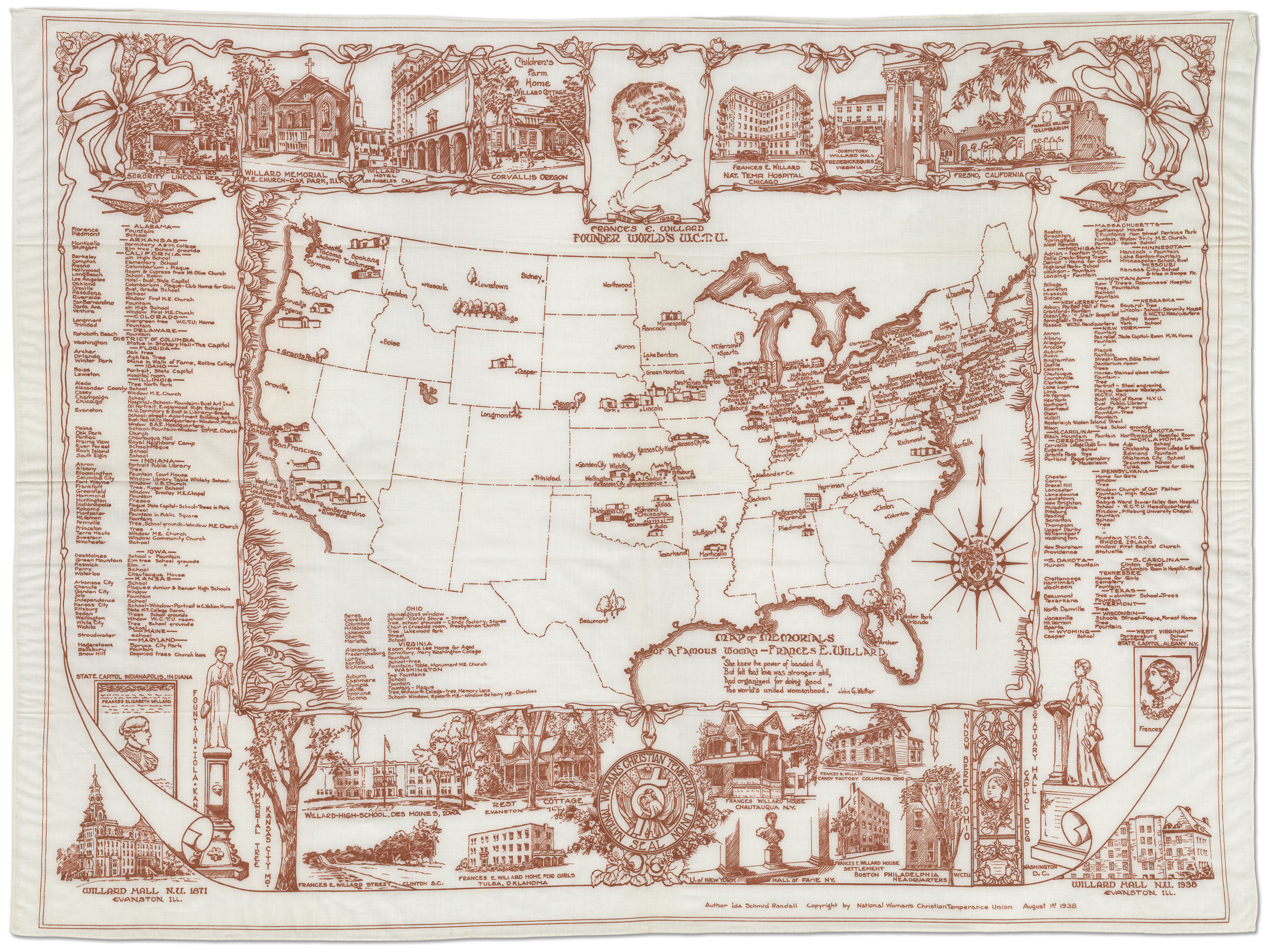
One of our favorite artifacts is this 36”x26” rectangle of cream-colored cotton, printed in brown with a map of the United States as of 1938. If you look closely, you can see that most of the states contain one or several dots. Each one indicates the location of a structure—school, statue, drinking fountain, park—that had been named in honor of Frances E. Willard, social reformer, leader of women, president of the Woman’s Christian Temperance Union (WCTU) from 1879 until her death in 1898. The map itself was one of many objects, projects, and events produced by the WCTU to commemorate the 1939 centenary of Willard’s birth (1839).
In April, 1938, in a letter describing the map project, WCTU president Ida B Wise Smith wrote, “Someone has said, ‘There are more memorials to Frances Willard than to any other woman,’ and we are attempting to prove this statement by gathering information as to where there are schoolhouses named for Miss Willard, where are hospitals, as in Chicago, settlement houses, as in Boston, Homes for Girls, as in Oakland, Tulsa, Toledo and Chattanooga, and so forth, in an almost endless, amazing list.”
After WCTU members all over the country reported to the National Headquarters in Evanston on the existence of memorials in their areas, the list of structures to be included on the Willard Centenary Souvenir Map reached 263. (By the end of the Centenary year, another 250 had been documented.)
The map was drawn by Ida Schmid Randall, “artist, architectural draughtsman, and experienced cartographer,” as the Union Signal described her (July 23, 1938). A sketch of Willard as a young woman is at the center top of the design. A number of the memorial sites are featured on the panels (including perhaps the most famous–her statue in the US Capitol), along with a full listing of all 263 buildings, statues, plaques, trees, drinking-fountains, and stained-glass windows. The ribbons and bows that tie the images together represent the white ribbon which has been the symbol of the WCTU since 1877.
According to correspondence in the Centenary files in the Willard Archives, the master map cost $400. The “cut” from which the map was printed was produced by Mr. M. Hermas of Evanston, and the maps were produced by Waverly Fabrics, in New York. A total of 8,800 maps were produced. WCTU unions across the US were encouraged to purchase a supply of the maps to sell or to distribute to local schools and churches during 1939. The maps were advertised in the Union Signal, the WCTU’s national weekly newspaper, starting in mid-1938, and went on sale for the first time at the National WCTU Convention in San Francisco in August, 1938. The Willard Centenary Souvenir maps were priced at $1 each (with discounts for quantity purchases).
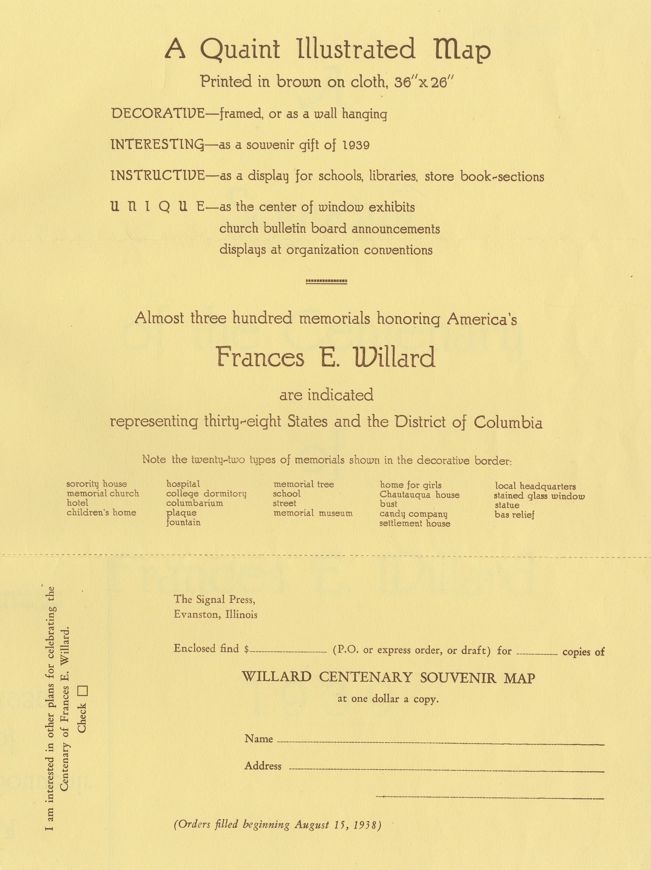
The first question we usually get when someone sees the map is, “What is it FOR?” The order form for maps listed a few possibilities, including a wall hanging for schools, Sunday School classrooms, or WCTU reading rooms, or as a backdrop for Willard Centenary displays. And each map came with a document that described its history, and listed, state by state, the memorials pictured on it. We can’t help but wonder how many uses the WCTU women found for this informative, inspiring, and versatile souvenir of Willard’s centenary.